Meet the experts behind The Changing Coast interactive website
SELC’s geospatial and coastal teams are making waves with the launch of The Changing Coast, a website and interactive map showing how rising seas and a changing climate are reshaping the Southern coast.
Explore our changing coast.
What will you discover?
Three SELC experts behind the project delve into what it reveals and how you can use it to explore our changing coast.


Q: As the leader of SELC’s geospatial team, you’ve worked on hundreds of maps that illustrate environmental threats including climate change and sea level rise. What makes this one different?
Jovian: With The Changing Coast, we’re building something we want the public to use and we’ve never done that before. This one is designed to provide coastal residents with a variety of information to understand what the future of their coast looks like. It’s designed to capture both the present and the future because a lot of planning scenarios don’t look far enough into the future, or use out-of-date projections.
Q: What are the benefits of making this information easily digestible and available to the public?
Jenny: It allows a much larger group of people to access the data and understand potential threats and new proposals. Our coast faces so many different types of risk and being able to see them all in one place helps paint a more realistic picture of our present and future.
Chris: Maybe there’s a proposed development slated to go in your neighborhood and you’re worried about how it may exacerbate flooding and impact you and your neighbors. A lot of this information is available if you know where to find it with different state and federal agencies or local governments. It might seem simple, but one of the key benefits of this tool is that it brings all of this information together. We put a lot of thought into how to make it simpler for folks who aren’t GIS experts to be able to use these data and get their arms around what’s happening where they live.
Why did SELC include the Social Vulnerability Index in the map layers?
Jovian: It was important to us to find a way to represent characteristics of how our coastal communities are structured, and that includes putting environmental justice up front. The best available data for our tool are in the Social Vulnerability Index (SVI), which is published by the CDC. It uses 15 U.S. Census Bureau data fields on things like race/ethnicity, socioeconomics, transportation, and household composition. The index allows us to look at communities as a whole and focus on the neighborhoods where there are concentrations of folks living with a higher risk of being impacted by weather disasters.
Q: Who’s going to use this website?
Chris: Our goal is that The Changing Coast will be used by ordinary citizens concerned about the places they live, recreate, and visit. This tool enables communities on the coast to consider appropriate, safe places to put new development as well as where building might be too risky or make flooding worse. It’ll also be useful for our partner groups who often call on us, but will now be able to use the tool to do an initial evaluation of a proposed project.
Jovian: It’s not designed to be just for scientists. It’s designed to pull a variety of information together and provide a way to share that with folks who are engaged on coastal issues, whether they’re a concerned resident, a journalist, or someone involved in local or state politics.

Q: What surprised or impacted you while working on The Changing Coast?
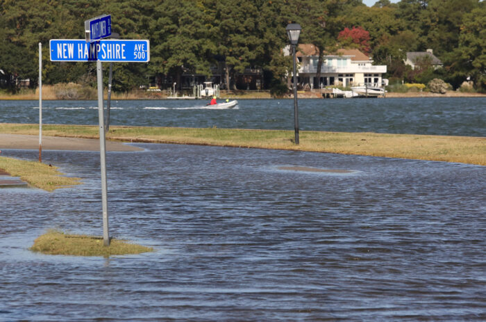
Jenny: One of the ways we realized this was going to be really helpful was looking at projects like Cainhoy, a development proposal that would destroy over 180 acres of wetlands outside Charleston. When you pull it up on the map, you realize that half of the land they’re slating to put 9,000 units on is already very flood-prone, and will be underwater from sea level rise in the near future. It really puts that project into perspective and highlights the need for better planning.
Chris: For me, it’s seeing the product of an idea that many of us have been working on and talking about for a long time. Our hope it that the GIS tool will enable better decision making about ways to grow in a more resilient fashion in light of climate change. As someone who lives in Charleston and has seen the ongoing development pressure and experienced the worsening flooding and more powerful storms, I know how important it will be for us to grow in a smarter way.
Jovian: Technical things I hadn’t considered before and the minutiae of what has to be programmed and accounted for, including all it takes to produce a map for other people to use in an interactive capacity. It was a completely different workflow. We played into the strengths and experiences of within the Geospatial Team to help inform a better overall experience of the product. Miller Cochran was very helpful in packaging and preparing data to go online. Some of the more statistical parts of making sure we were applying demographic data in an appropriate context — that’s where Libbie Weimer came in.
Any tips for using the interactive map?
Jovian: Users should look at this as a way to understand their community, not their individual homes. It’s designed and intended for community-level planning because the data are not clear or accurate enough to represent what’s really happening on a house level.
Resist the urge to turn all the map layers on and zoom all the way in. We’re honoring the scale the data were drawn at, and as you zoom in further than we’ve allowed for, some of the layers turn off, ensuring users are not presented with inaccuracies.